Percy Priest Lake is the largest and closest lake to my house in Hermitage, TN and as such, makes for an excellent place to explore via canoe when the weather is perfect and the wind is just right. The lake provides us landlocked folks an escape from the hustle and bustle of the city and the quiet solace of the tides lend themselves to leisure. Most people, myself included, likely take the lake for granted, simply enjoying the cool, inviting waters on a nice summer day without much thought, but just like Nashville Shores (I used to lifeguard there in 2003) it is a more recent phenomenon.
The lake was formed after the completion of J. Percy Priest Dam in 1967 by the U.S. Army Corps of Engineers. The name of the dam project and the reservoir was originally the “Stewarts Ferry Reservoir” but was later changed by an 1958 act of Congress to its current name. Nothing against Congressman Percy Priest (I never knew the guy) but I wish the lake had retained its original name since it payed homage to the regional history better than the current name. Stewarts Ferry, as I’ll show later in pictures was in most recent times (pre-1967) a cable ferry across the Stones River. Before the invention of a cable system, it was likely a boat ferry, although the latter is purely speculation on my part as it is rather difficult to find information on the subject.
Before the U.S. Army Corps of Engineers flooded the low lying farmland to create the lake, several of the present-day disconnected sections of roads, most notably: Old Hickory Blvd, Stewarts Ferry Pike, Smith Springs Rd, Lavergne-Couchville Pike, and Bakers Grove Rd, all ran through the network of farming communities. This is quite easy to see using the “Satellite” view on Google Maps.
Flash forward to the perfect day that was yesterday and bearing in mind the aforementioned information, I set out from the Nashville Shores Marina in the “Big Blue Beast,” aka my dad’s 17′ Blue Hole whitewater canoe, with the intent of finding the “lost” sections of Old Hickory Blvd (OHB) and Stewarts Ferry Pike (SFP). And for those who are wondering where the canoe’s name came from, if you’ve ever tried to tandemly maneuver a 17′ canoe in whitewater (that just so happens to be blue), its analogous to a semi-truck merging across 4 lanes of traffic: a beast of a thing to do! After 2 km of paddling around the Nashville Shores peninsula I arrived at the sunken section of OHB, which is quite easy to miss from a distance unless you know what to look for!

View of Old Hickory Blvd looking south from Percy Priest Lake. This worn piece of road is all that remains after 47 years of lake tidal action!

View looking north from above position with the submerged section of Old Hickory Blvd heading into the center of the picture. In the clearing in the center of picture is the present-day road.
Continuing south for 0.5 km around the shoreline I came upon another section of OHB, this one quite large and above the waterline! After landing the canoe on the shoreline, I got out to walk the old road and explore the area! From the beer bottles and other bits of trash it appears that those people with faster modes of nautical transportation have frequently been here. But no matter, it was still good fun exploring and shooting photos of the area! I even came across what appears to be a bald cypress tree! I was quite surprised to find one in the lake as they’re normally found in swamplands and other wetland areas.

Looking north of an exposed section of Old Hickory Blvd with the Big Blue Beast beached on the shoreline.

The most surprising find of the day: a bald cypress tree in the lake!
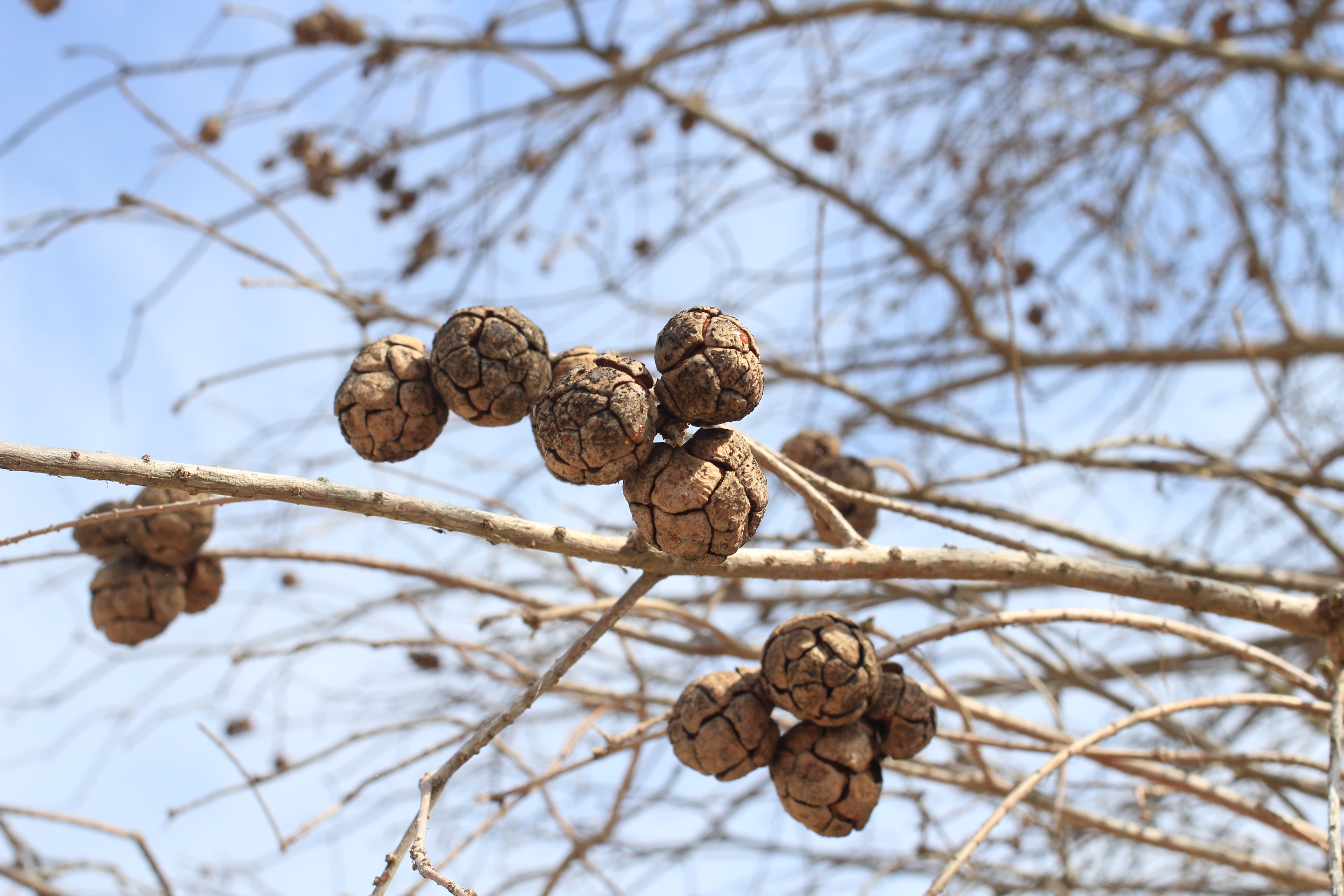
Bald Cyrpess Cones! I never thought I’d see these naturally in Middle Tennessee!
NOTE: From here OHB continues to the Cook Public Use Area, a local park and boat launch ramp. The area is quite lovely, especially now with the flowing trees, and has plenty of picnic areas and pavilions for outdoor entertaining.
After packing my things, the Big Blue Beast and I continued for another 8 km to what I’ve named “Stewarts Ferry Island” since this section of SFP is normally encircled with water during higher water levels. Upon arrival it is immediately apparent that this used to be the cable ferry crossing station. I’m glad that vandals or others interested in sign memorabilia haven’t torn down the signs and removed some of the last remaining historical elements of this pre-lake history! Although my pictures don’t show it, the area does have several places to camp. The cable crossing sign and some building foundations are all that remain of this once important river crossing point.
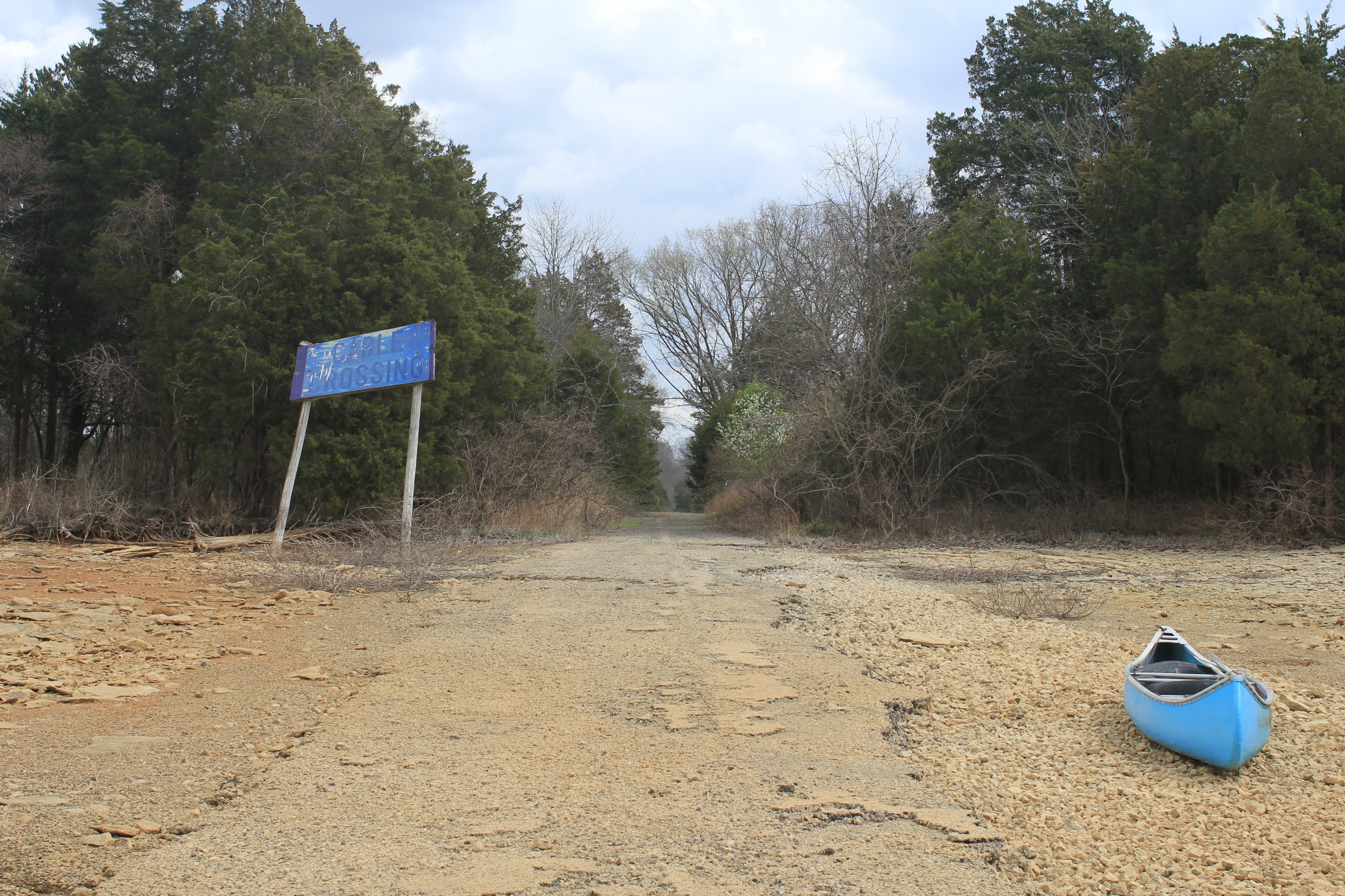
View looking east of Stewarts Ferry Island with old cable crossing sign and the Big Blue Beast on shore.

View looking west from the island of Stewarts Ferry Pike. This was once a cable crossing point of the Stones River. On the far shoreline you can see another blue sign and the old section of SFP.

View looking east from Stewarts Ferry Island toward eastern shoreline. Only the island-section of the road remains. Note on far shoreline the old section SFP continuing through the woods.

View looking south of the eastern side of Stewarts Ferry Island.

View looking west from Stewarts Ferry Island. Note the old building foundations. I looked around for clues of their purpose but was unable to find anything.
Unfortunately, due to time constraints (I had to make a birthday dinner) I wasn’t able to continue to the last remaining lake-section of SFP, which is another 20-30 minutes of paddling east. I will save that for another day. After taking the above photo, I returned to the canoe and the Big Blue Beast and I set off for the Nashville Shores Marina. All in all, I paddled 18.2 km and had plenty of adventure to show for it! Its amazing what can happen when a persons says “I wonder…..” and then follows it up with action!

Great story and adventure!
I would hope your readers know that the Corps of Engineers pulled …500 plus acres stolen from my Aunt Mamie Raider at a dismal $100.00 an acre or else we will take it in 1964 she had no choice. I hope everyone enjoys the section of the lake she was forced to share with yall. And now they have sold it to development at Williamsburg DEVELOPMENT off bell road near Hamilton Creek because it was uneeded. Thanks big government. Yall SUCK.
Wonderful article on Stewart’s Ferry Pike. My Ellis ancestors owned land on that Pike in the 1830/40s. On many trips through Nashville I see the Stewart’s Ferry Pike sign and long to know more. I love the pics!